In the wilderness of the Wicklow Mountains, Fran and Conal decide to climb go up a hill. The view from the top was epic.

By Conal Healy
Thursday, October 14, 2023 (10am): “Let’s go climb a mountain” suggested Fran. It wasn’t something I was expecting.
We had watched the dawn at Bray, stopped for morning tea in Greystones and had stopped in a forest car-park high up in the Wicklow mountains.
The scenery on that bright, clear morning was nothing short of spectacular.
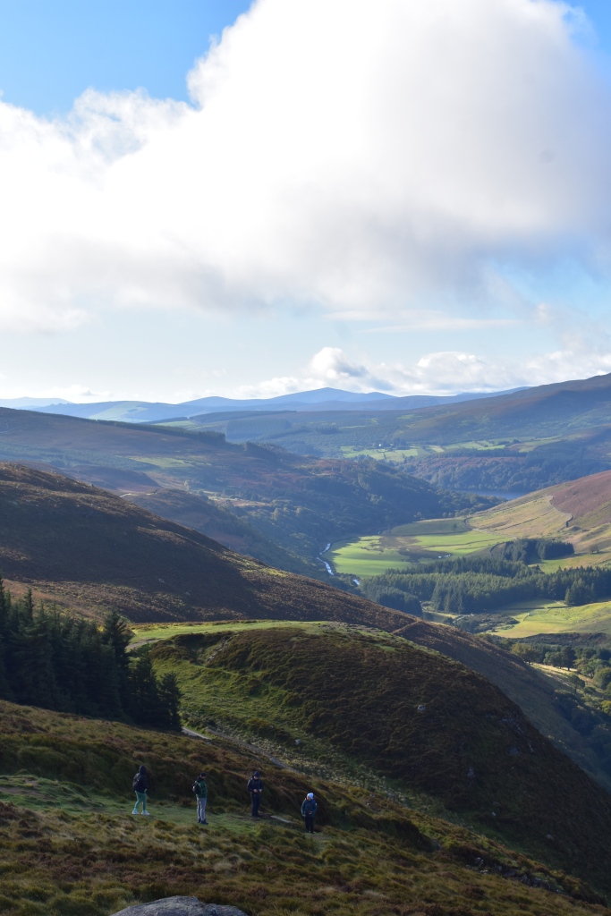
The Wicklow Mountains might be 60 kms south of the major European city of Dublin … but we were now looking a landscape almost devoid of humanity.
One hiker likened the scenery to something out of Lord of the Rings – epic, dramatic and largely empty. Fans of the film Braveheart will know that the Wicklow Mountains were used as substitute film locations for Scotland.
Fran and I started the The Sally Gap Drive at the village of Roundstone. A guide book suggested the drive should take about 60 minutes, “allow for at least twice this for stops along the way” it suggested.
The road (known as Old Military Road) at the Sally Gap in Wicklow was built shortly after the Irish Rebellion of 1798. The road was constructed by the British Army who wanted to drive Irish rebel forces from the area.
Our first stop was the aforementioned forest car-park (JB Malone Car Park) that overlooks Lough Tay (also known as the Guiness Lake). Like most people, we ignored the warning signs and ventured to see the small but scenic lake.
Thanks to a long camera lens I could pick out some interesting features of the estate currently owned by members of the Guinness family trust that lies between Djouce Mountain and Luggala.
As we returned to the hire car, Fran spotted a forest trail that snaked up a hill. She was curious. From the lake lookout we could see a path leading to a mountain peak. We could see people walking the track. Wonder what the view would be like from up there? I said to myself.
Fran must have read my mind and suggested: “Let’s go climb a mountain!”
(My mind was elsewhere, we were literally in the middle of nowhere and my mind was starting to think of finding a nice pub for lunch before hitting the road for an afternoon of sight-seeing.)

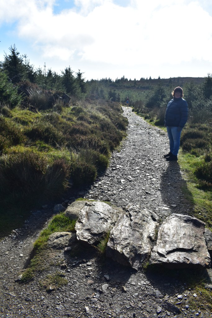
“Why not” I replied. And we set off to climb Mt Ballinastoe.
There is a path which goes through the pine forest. The walkway, we are assured is one of the most magical places in Ireland – “It’s a fairytale place” according to thirdeyetraveller.com.
“This part of the woods looks like an Elven forest and you’ve been transported to Middle Earth in the Lord of the Rings. It’s such a magical place to take photos and videos and if you catch it in the right lighting it looks surreal.” It continued.
Sadly, this part of the track it was shut the day of our visit. We set off up the track, past the Scots Pine forest, up to the open heather moor land. There is a good – if narrow – boardwalk that makes the walk easier.
In general, the trail is exposed on the upper slopes and can be very windy in poor weather.
Due to the longer daylight hours and more favourable weather conditions it is recommend that you visit the Wicklow Mountains anytime from March through to October.
If you are thinking of completing the Wicklow trails during the other months of the year, there is a high possibility you will be met with adverse weather conditions including ice, snow, or storms, along with shorter days of daylight.
At sea level in Wicklow the temperature was probably around 10 degrees, on top of Mt Ballinastoe is was a cool 6 degrees and with a stiff breeze it felt like 3 degrees. Fran and I were wearing coats, scarves and woolen hats.
Wicklow’s climate is mostly mild. If it is sunshine you are looking for, then July and August are often the best months as temperatures range between 14-16 degress. The coldest months in Ireland are January and February with average temperatures ranging from 4-7degrees.


The track is graded as Easy. It is sign posted. Distance? Just over 5kms with an estimate time of 1.25 hours. Suitable for anyone with average fitness. At the highest point you hit 530 metres and the view is panoramic (on a clear day).
After months of rain, the raised track made the climb easier, stepping off meant a soggy, boggy reception underfoot. We were not alone by any means – we were joined by athletes in training, long distance endurance runner and young couples taking their dog for a hill walk.
At one stage Fran and I were overtaken by a noisy group of young men with rucksacks. They were having no trouble with the gradient, didn’t seem too interested in the unfolding mountain vista surround them.
They charge ahead of us to the seated area known as the JB Malone lookout. They sat down to maybe drink in the view? Nope, they were stopping for a beer break. It seems that their backpacks were well stocked with cans of beer. They might have been hikers, but they made sure they stayed hydrated with Dutch lager. And, in fact, discussed whether cider was better than beer while hiking.
Fran and I walked on, aiming for the top of Mt Ballinstoe.
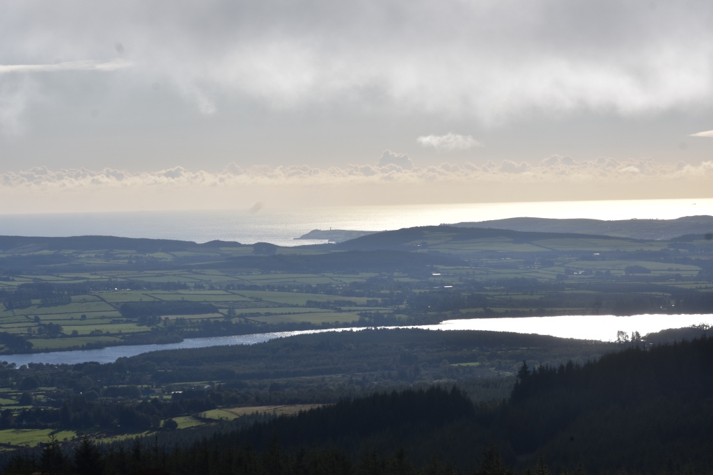
The view from the top was gobsmackingly awesome. We could see the Irish Sea below us and the Wicklow mountains stretching before us. This was an empty landscape. Spectacular and desolate.
Wild, yet gentle.
The Wicklow Way: Just the facts
The Wicklow Way is now part of a network of long-distance self-guided walking trails, (also called ‘way-marked ways’), throughout Ireland. The Wicklow Way combines easy accessibility with a wide variety of scenic experiences, some of them in truly remote upland areas. They include mountains, upland lakes, steep-sided glacial valleys, fast flowing mountain streams, forests and farmland.
The beautiful landscapes of the Wicklow Mountains National Park are the perfect escape from city life. Walks in the Wicklow Mountains have something for everyone: from gentle dog walks through picturesque glens to rugged mountain adventures amongst the largest area of upland in Ireland.
How long does it take to hike the Wicklow Mountains?
Due to its sheer vastness, the Wicklow Mountains is divided up into several trails.
Below is an average of how long it would take to complete each of these comfortably while being able to soak up the spectacular surroundings:
The Wicklow Way: 7-10 days
Glendalough Loop: Approximately 3 hours
Trooperstown Hill: Approximately 3 hours
Avonmore Way: Between 3-4 hours
St Kevin’s Way: 4-5 days


Leave a comment