Google Maps has led Fran and Conal across country, off the main roads, and beyond the tourist track … to a largely ignored 1000-year-old monastery.

Wednesday, October 11, 2023 (Late Afternoon): Any decent drive in Ireland will take you past a ruin of some kind. Usually, it’s a 500-year-old castle. Or an 150-year-old Famine Era stone cottage, or a manor house burned down during the Irish war of independence a century ago.
The conversation in the early part of the drive starts with an excited exclamation: “LOOK! A RUIN!” There is an implication that perhaps the car could be stopped so the “ruin” could be explored?
After the third, fourth or six ruin, the conversation is “…Oh there’s another ruin over there … but as I was saying…”
Fran and I were driving through County Galway, bound for Lahinch, Google Maps was directing along ever-narrowing roads. It was now late afternoon, and I had a desire to stand on the beach at Lahinch and watch the sunset into the Atlantic Ocean. (Living on the east coast of Australia you rarely get to see a watery sunset.)
It seemed a clear run to a sunset (maybe with a drink in hand) when we came around a tight corner and came almost face-to-face with a 1000-year-old monastic site. There was nothing marked on any of the maps. Google Maps didn’t mention it.
Australian Fran saw the round tower and the stone buildings and shouted “STOP!” This was a ruin she wanted to explore.
If you are Irish, you become blasé to ruins. We have monuments older than the pyramids in Egypt laying about in Ireland. Fran was born in Murwillumbah, an Australian town that was established in 1880. She has a different sense of history to me.
So, we pulled over the explore the Kilmacduagh site – it was down a down a narrow, stone-wall lined lane. (In Ireland we call them a boreen.)
On the bright autumn afternoon, we were among a handful of people exploring the ruins of the spread out site. We were way off the tourist track here.
ON SITE
Kilmacduagh sits at the edge of the Burren, dominating the rural landscape some 5km south-west of Gort, in County Galway. The is low-lying land, a flat landscape of green fields roll to the horizon. In the nearby fields cows low, it is coming up to milking time. The cows are waiting to go home.
There is a car-park, there is a bi-lingual signage to explain the history of the site. We digest it, and push through the gate – there is no admission fee, no tourist guide to explain the importance of the site … in fact there is nobody here.
We walk down the gravel path, past gravestone, occasionally we step off and stand in the lush grass. The ground feels boggy underfoot.
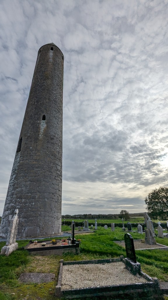
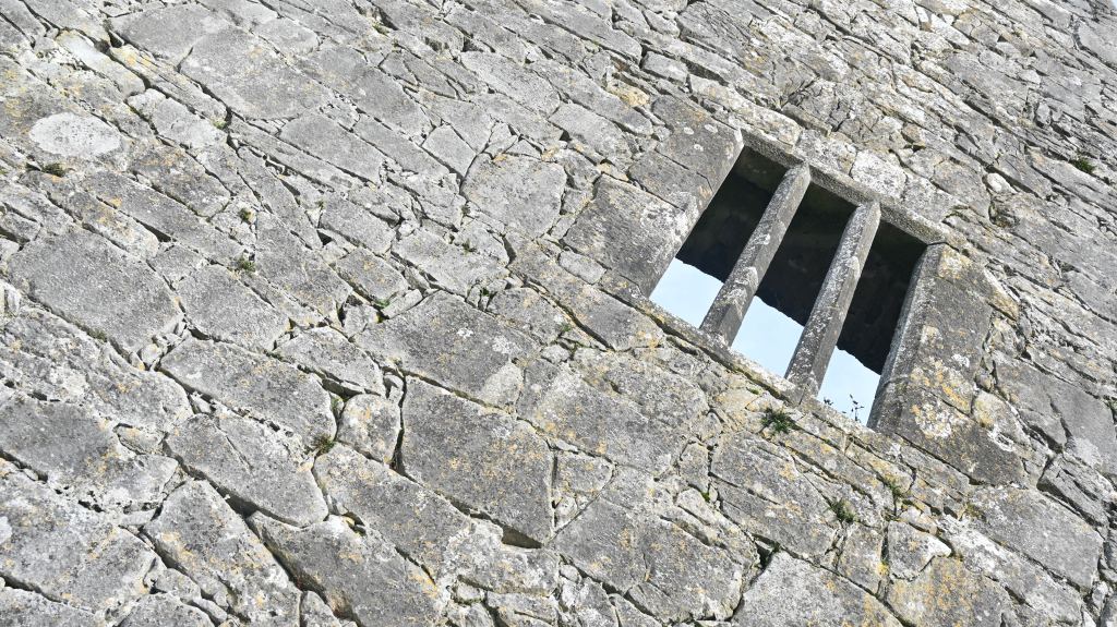
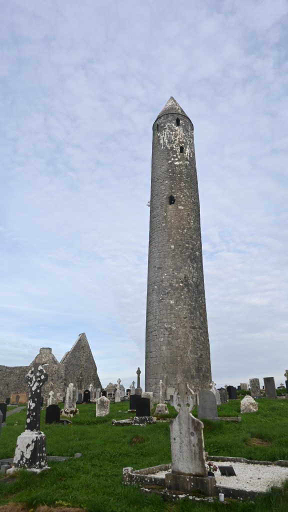
The round tower is the only non-ruin building on site. I looked up at the only doorway into the tower (about seven metres above ground level), and wonder what the view would be from the top windows – in this flat landscape you would have been able to see forever.
Is there a stairway inside? Did the monks use ladders to get to the top? What was it like inside? These were questions that would not be answered today.
GOLDEN YEARS
Kilmacduagh dates back to the time of The Land of Saints and Scholars. This began with the collapse of the Roman Empire. Europe fell into the Dark Ages, but Ireland was an isolated Island, so it was able to continue to prosper and evolve. This led to a Golden Age of education, art, literature, and culture, during which saints like St Patrick became legendary.
In the medieval period, Kilmacduagh was the most important church of the Uí Fiachrach Aidhne, a powerful local dynasty who held lands that stretched from the Atlantic coast to the mountains of The Burren and Slieve Aughty.
By the 12th century, Kilmacduagh had an enclosed settlement with the main church at the centre, at least three subsidiary churches, a round tower, the grave of the founder, Cólmán mac Duach, and a well dedicated to him.


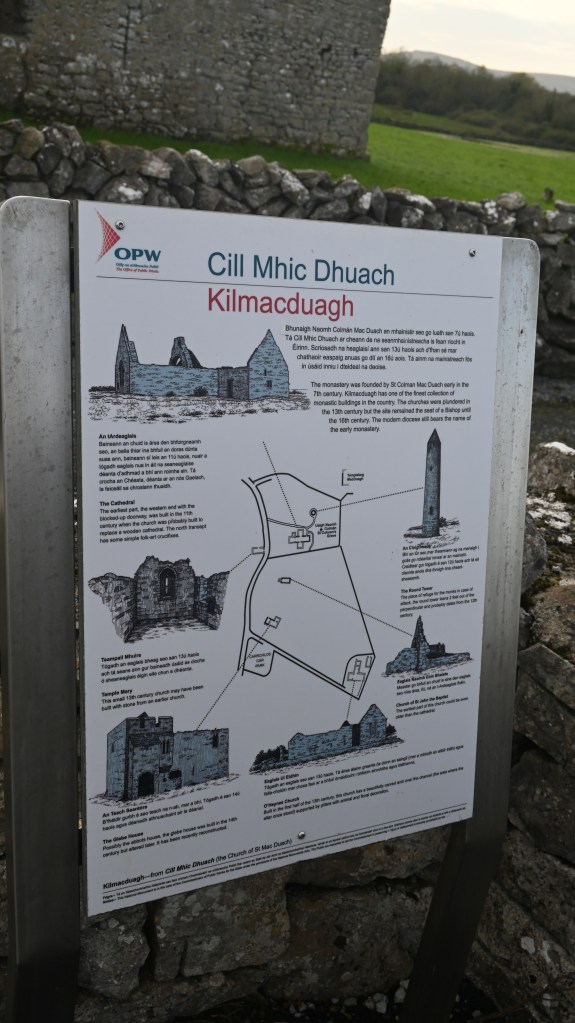


The settlement was transformed when the main church was enlarged as a cathedral and a monastery for Augustinian canons was established in the 13th century.
The monastery, because of its wealth and importance, was plundered several times in the lawless years of the 13th century. The interesting stonework features scattered throughout the small churches are worth searching for; these are mostly inserts from the late 11th to the 15th centuries.
The Reformation effectively brought the religious life of Kilmacduagh to a close (in the 16th Century).

The round tower is notable both as a fine example of this particularly Irish feature but also because of its noticeable lean, over half a metre from the vertical.
The tower is over 30 metres (98 feet 5 inches) tall, according to measurements taken in 1879, with the only doorway some seven metres above ground level. The tower probably dates from the 10th century.
BACK ON THE ROAD
Fran and wandered around inspecting the ruins, taking photos and enjoying the site (almost) by ourselves.
And, not for the first time, amazed something so historic was not overrun by tourists and very badly signposted.
We climbed back into the hire car and checked the time – we had an appointment on a nearby beach with a setting sun and the nearby Atlantic Ocean.
What were Irish round towers used for?
The most popular theory is that the towers were used for defensive purposes. The monks took their treasures and hid inside the tower where they would be safe from raiders. The doorway, high up in the wall, made it difficult for unwanted guests to gain entry. Another theory is that the towers were used as bell towers.
Round towers are generally encountered at the locations of ancient Irish monasteries. Although the monastic sites typically originated in the 6th century, the stone towers did not appear until the late 9th century and the building of such towers continued until about the 12th century.


Leave a comment